To continue our series on significant highways, let’s look at the first coast-to-coast highway in America: the Lincoln Highway. We’ll show you why they call it the Lincoln Highway and its struggle to become a recognized highway.
November 9, 1921, is an important date for the RV community. One of the most fundamental pieces of legislation became law by the 67th United States Congress and the 29th President, Warren G. Harding, on November 9, 1921. The Federal Highway Act of 1921 was the second, but most significant law, that gave us our modern highway system.
Even though it no longer exists as an active highway, you’ll learn the route numbers of the Lincoln Highway and how you can still drive the Lincoln Highway. You’ll learn the many contributions the highway and its parent organization contributed to trip planning and highway travel. We also point out some key Lincoln Highway attractions and included an interactive Lincoln Highway Map so you can plan your next cross-country trip!
Fun Facts
- The Lincoln Highway Association provided travelers with guidebooks as thorough as today’s best trip planning apps and travel blogs.
- The Lincoln Highway created the construction process for modern roads.
- In 1919, Lieutenant Colonel Dwight D. Eisenhower led a military convoy from Washington D.C. to San Francisco on the Lincoln Highway.
What was the Lincoln Highway?
The Lincoln Highway was the first transcontinental highway established in the United States. From 1913 to 1928, the original Lincoln Highway Association (LHA), sought to grade and ultimately pave this 3,389-mile road across America. Funding for it came from private citizens and corporate sponsors.
The road started in Times Square, New York City, NY, and terminated at Lincoln Square in San Francisco, CA. There were updates to the route during the 15-year project, but the original road traveled through the Snowbelt states:
- New York
- New Jersey
- Pennsylvania
- Ohio
- Indiana
- Illinois
- Iowa
- Nebraska
- Wyoming
- Utah
- Nevada
- California
The LHA added a branch that ran through South Bend, IN, Elkhart, IN, and ended at the front porch of the LHA in Detroit, MI. They offered, but never built, an auxiliary route between Philadelphia, PA, and Gettysburg, PA. This addition would’ve made a connecting branch to Washington, D.C. It also later extended into Baltimore, MD, Frederick, MD, and Wilmington, DE. Finally, the LHA added a branch for Chicago, IL.
When you look at the interactive map, you’ll see that there were three generations of the Lincoln Highway. Each generation occurred due to the development of the project. Some sections needed to be straightened, avoid overall harsh road conditions, or other concerns.
The Lincoln Highway Association and Carl Fisher
The idea started in 1913 with entrepreneur Carl Fisher. Before his Coast-to-Coast Rock Highway (the original name), Fisher’s resume included building his fortune as the creator of the Prest-O-Lite compressed carbide-gas headlights used by most automobile manufactures of that time.
He also turned a piece of farmland into a brick-paved racetrack in Indianapolis, IND (hence the Indianapolis 500). He transformed a significant portion of South Florida swampland into posh beach resort property we now know as Miami Beach, FL.
His primary partners on the Lincoln Highway project were Henry Joy, President of the Packard Motor Car Company, and Frank Seiberling, President of Goodyear Tire and Rubber Company. To fully fund the project, Fisher figured he needed $10 million to create the route and develop the road using gravel as a water drainage technique, making it ideal for automobiles to use.
Getting to the Exhibition on Time
To do this, Fisher called everyone he knew in the auto industry and other prospective donors for an investor dinner at the Deutsches Haus (German House) in his hometown of Indianapolis. He told them that he wanted to have the highway completed by May 1, 1915, a mere two years from that point.
The significance of that year was important then but would be astronomically crucial for the future. From February to December in 1915, San Francisco, CA, hosted the Panama-Pacific International Exhibition. This world fair celebrated the completion of the Panama Canal and the city’s revitalization nine years after the devastating earthquake it suffered. Visitors could see the many marvels presented in the hundreds of pavilions scattered over the 600 acres from virtually everyone and every company with an idea for the future.
One of the most significant pavilions was the four-acre replica of Yellowstone National Park. Union Pacific Railroad created this half-million-dollar pavilion with working geysers to promote interest in creating the U.S. National Parks. Learn more about how this investment turned out for this railroad company at the beginning of our RV Era Series article, The Antique Era.
If Carl Fisher could have his Coast-to-Coast Rock Highway completed by the beginning of May 1915, that would be the time where people would be hitching up their tent trailers to their Ford Model T. But, more importantly, donors would be setting out in their Touring Landaus (or other luxury vehicles), heading to the International Exposition. What better way to promote the highway than out-of-towners using the road.
Unfortunately, prospective donor holdouts like Henry Ford had other ideas. Ford stood firm on the idea that building roads was a government issue. So while the dinner did produce some results, Fisher and his partners walked away with $1 million in pledges. Of course, it wasn’t what they were hoping for, but it did give the group enough to get started.
What Does a Million Bucks Get You in 1913? A Mile of Pavement and Marketing
After some preparation, Fisher and Joy took a two-pronged approach. Henry Joy had the idea of renaming the Coast-to-Coast Rock Highway after the 16th United States President Abraham Lincoln. He even wanted to eventually add a commemorative marble memorial that would cost $1.7 million. Joy thought he could earn some “brownie points” with the federal government by giving the highway a patriotic name, thereby loosening their purse strings. It didn’t work, but it was a good plan.
Once he established the Lincoln Highway Association in Detroit, MI, and was elected its President, the members liked the name and voted on it. The LHA immediately started working on promotional and marketing materials, including lobby materials, pamphlets, newspaper advertisements, and other fund-raising programs.
On July 1, 1913, while Joy was gavelling the LHA into its first session, Carl Fisher was voted in as the Vice President in absentia. Fisher was in Indianapolis preparing for the “Hoosier Tour” (also known as the Trail-Blazer tour). Carl would lead the Indiana Automobile Manufacturer’s Association representatives with 17 automobiles and two trucks for 34 days to San Francisco, CA, to figure out the actual route of the Lincoln Highway.
Until Fisher returned, Henry Joy wouldn’t even hint at the final path of the roadway. (For all of you MCU fans, imagine how frustrated you get with Kevin Feige, and you’re not getting any leaked info from your favorite media source). This created problems for Joy since he was receiving pressure from the Governors of Colorado and Kansas.
The two State Officials the highway routed so that it ran through Big Springs, NE, cut through Denver, CO, and reconnected to the original highway plan at Cheyanne, CO. When the final route was announced, Colorado and Kansas didn’t even get a secondary branch. Years later, the LHA would have to add additional information on the official map telling travelers to avoid signs directing them down this unofficial route. (From the Governor’s point of view, travelers mean tourist revenue).
During the Hoosier Tour, Fisher and his caravan fought through mud, sand, and other harsh conditions trying to find the best route to take. Since the tour was highly publicized, the Hoosier Tour would be well-received every time they drove into any type of city center. Carl Fisher would take this opportunity to meet the key people and gather other intelligence for future plans.
When the Trail-Blazers finally reached San Francisco, the city gave them a hero’s welcome down Market Street. It included a parade with thousands of cheering residents. After the celebration, Fisher and his team left quietly by train back to Indianapolis. Fisher would continue to Detroit to report his findings with Henry Joy and the LHA.
Consul Ambassadors and Bonds
On September 14, 1914, two months after the Hoosier Tour began, the Lincoln Highway Association announced the official route of the highway. Unfortunately, a significant portion of disappointed townspeople who had celebrated when the caravan came to their town read the news heartbroken since the road wouldn’t be going through their area (especially two State Governors).
The 3,389-mile Lincoln Highway took advantage of some existing roads and other various features:
- Almost 1,600 miles had improvements already, including pavement- mainly in the East.
- In New Jersey, the Early Dutch Colonists had laid out a road that dated back to 1675.
- The Philadelphia-Lancaster Turnpike of 1796 and the Chambersburg-Pittsburg British Military Trail of 1758 (later known as the Pittsburgh Rd./Conestoga Rd.) had over a century and a half of solid construction already in Pennsylvania.
- The original Native American Ridge Road in Ohio dated back to the pre-Colonization period.
- The Lincoln Highway connected the Mormon Trail, Overland Stage Line, and sections of the Pony Express Trail in the West.
- For the final leg of the journey, the Lincoln Highway used the Donner Pass in the Sierra Nevada Mountains to enter California.
The dedication of the highway took place on October 31, 1913. Celebrations took place along the highway. You could see bonfires, fireworks, dancing, concerts, and other forms of ceremony and celebration.
The LHA enacted Phase II of their goal by putting the pedal to the metal. They continued their lobby efforts in Washington D.C., increased their donation program, developed a series of guidebooks, and brought on a team of consul ambassadors along the route.
The Consulmen like J.M. Rawlins or Rawlins, WY, would act as ambassadors for the various counties the Lincoln Highway passed through. The LHA issued memberships to these men as go-betweens for the people and the Association. Travelers could stop by and ask questions about the route, where to find things they need, and buy Lincoln Highway Bonds to fund the construction of the highway (essentially, they were human RV LIFE Trip Wizards).
The Guidebook
The LHA also released guidebooks giving travelers vital information to prepare and travel the route. There were multiple editions published.
- The first edition came out in 1915.
- You can read the second edition of The Complete Official Road Guide of the Lincoln Highway through Google Books.
- The 1918 third edition is available through the Internet Archives online resource.
- The fourth edition was published in 1921
- The fifth and final edition was released in 1924. Original copies can be purchased on Amazon.
The guidebook’s first section helped readers prepare themselves and their automobiles with a list of provisions, spare vehicle components, and tools needed for the trip. They’d also find information about distances per state, driver license requirements, and a map inside the back cover.
Most of the book gave travelers details about every city and town along the roadway. Readers could find the name of the Lincoln Highway Consulman, and the many features the town provided like:
- Banks
- Express companies (to send or receive mail/packages)
- Garages/service stations
- Lieutenant Colonel businesses
- Hotels
- Newspapers
- Public schools
- Public transportation and utilities
- Road Improvements
- Speed limits
- Telephone and telegraph services
- Interesting geologic landmarks
- Other points of interest
The Ideal Section
The first million Charles Fisher and Henry Joy earned covered the costs of the Hoosier Tour, establishing the Lincoln Highway Association headquarters, the initial lobby, and promotional materials. The volunteer members of the Consul Ambassador program and bond program may have tapped out that initial pot but created a whole new revenue stream.
The promotional tour down the Lincoln Highway drew in over $5 million from the “Peacock Road” (a slang term meaning wealthy) donors, all the way down to the average Americans who could just afford a $5 bond.
As the story goes, a small group of children from Anvik, AK, gathered their pennies together after their teacher discussed the Lincoln Highway. When the LHA received the “Fourteen pennies from Anvik Esquimaux children for the Lincoln Highway,” the picture and the attached letter were reproduced and widespread.
Henry Joy decided that private funding wasn’t going to realize the full dream of a fully paved highway, so he gave up on the fund. Instead, he changed tactics and steered the LHA on a new course. Their new directive was to promote the benefits of concrete roads through educating the people and use state funding to complete the highway.
Joy decided to create “Seedling” Miles in each state. At specific sections, the LHA would work with the state, county, contractors, and others to build a 1-1.5 mile section of road that was fully paved and used the latest technology in road construction. These seedling miles would be highly promoted to show state officials and the people what was possible for the Lincoln Highway.
The LHA chose Malta, IL, as the first Seedling Mile site. The most famous of the seedlings is the one in Dyer, IND. It was constructed in 1922 after a nationwide search of engineering proposals and research. The section used 18 different design principles. Some of which included:
- Making the concrete 10-inches thick
- Reinforcing the concrete with steel bars (rebar)
- Using specialty methods for bridges that have massive weight limits
- Banked elevations and guard rails
- Gutters that directed rain off the road
- Give the road a crowned surface where the center is the highest point to direct rain to the sides.
The renewed interest came from what the World War I veterans saw in Europe. Moving military equipment through Europe during the Great War occurred quickly due to the centuries-old roads that date back to the Romans. During Lieutenant Colonel Eisenhower’s 1919 military convoy from Washington D.C. to San Francisco, CA, vehicles broke down, became stuck in the mud, and had other problems. Developing good roads now became a military problem instead of a civilian inconvenience.
The Dyer, Indiana Ideal Section started construction in 1922 and used federal funding, state money, county tax-funding, private company sponsorships, and donated concrete. It stretches 1.3-miles long and hasn’t required many repairs (we know, don’t say it). Unfortunately, if you drive along U.S. Highway 30 today, you wouldn’t know if you’re driving on the Ideal Section since there aren’t any road indicators.
Between Great Lakes Drive, west of Northwinds Drive, you’ll see a monument dedicated to the Ideal Section on the south side of the road. Make sure you plant your flag on RV LIFE Trip Wizard, making this a must-see. There isn’t any parking at the monument, so the best place to park is the shopping center west of the monument. It’s not much of a walk, but you’ll find it worth the effort.
Once the Ideal Section finished in 1923, it was the top story in every newspaper around the country and trade magazine. That road construction you passed through earlier today uses the same building techniques the designers of the Ideal Section created almost 100 years ago (with some modernization of course).
The Federal Highway Act of 1921
Have you ever had a dream, but someone else had a better version? Many of you may remember that birthday or holiday you unwrapped your Atari. Nintendo came along and you were mowing the lawn or doing extra chores to save the Princess from Bowser.
You may also remember going online for the first time with Prodigy. Soon after, AOL came along, and on it went. How many times have you bought the same music album so you could play it on your record player, 8-track, cassette player, CD player, MP3, iPod, and internet radio player (extra points if you still have the original pressing of the record)?
Woodrow Wilson’s Highway Act of 1916 opened the roads to the public, but it was the Federal Highway Act of 1921 of President Harding’s time that spelled out the demise of the Lincoln Highway. The Act of ‘21 delineated the minimum standards the federal highway routes and the rules the states had to follow if they wanted their 7% of the pledged $75 million the federal government promised.
Many Governors decided that other roadways had their state’s best interest, so the road improvement money went that way. By the end of 1927, The Lincoln Highway Association declared defeat. Most of the Lincoln Highway became U.S. Highway 30, but small pieces are a part of:
- U.S. Highway 1
- U.S. Highway 40
- U.S. Highway 50
- U.S. Highway 530
The Boy Scouts of America Commemorate the Lincoln Highway
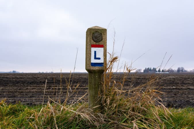
On September 1, 1928, the Boy Scouts of America coordinated their various troops along the original route. Each troop placed small markers made from concrete with the depiction of Abraham Lincoln in a copper bust. Around the circular edge of the bust, it says: “This highway dedicated to Abraham Lincoln.”

When the City of Dyer, IND, updated and rededicated the memorial of the Ideal Section, they also invited the local Boy Scout Troop to place a recreated marker to honor the highway.
The Lincoln Highway popped up now and again throughout the years. In the 1940s, NBC aired a radio show for two seasons using the highway as a backdrop. It has a loose thematic connection to the Route 66 TV show of the 1960s.
In 1992, the Lincoln Highway Association reactivated. Its new goal is to preserve the memory, artifacts, and stories of the first transcontinental highway in the United States.
How Long Does it Take to Drive the Entire Lincoln Highway?
The time it takes to drive the entire Lincoln Highway depends on several factors. For example, if you start in Times Square, New York City, NY, and take it to Lincoln Square San Francisco, CA, non-stop, you’re looking at 4-5 days. On the other hand, if you use the 2-2-2 RV travel method, stopping at all of the best attractions on the Lincoln Highway Association Map, the drive could take weeks.
You may want to check with the LHA and sign up for their guided tour coming up in 2022. However you decide to experience the Lincoln Highway, it’s one of those RV cruising trips that make our lifestyle worth it.
If you want to learn more about the highway, here’s a list of books from great authors who’ve written about the road. One or two are fiction, but like Steinbeck’s Grapes of Wrath, the author uses real locations on the road to tell their fictional story.
If you read the Lincoln Highway Association’s Guidebook from 1916, they said it would cost you about $5 a day traveling the road (yeah, we wish too). To help you budget your trip, make sure you’re using the expenses section on your RV LIFE Trip Wizard app to determine your actual daily costs. The planner will also help you find RV-friendly gas stations, the best campgrounds and help you avoid congested city streets. Of course, the best way to solve a problem is to prevent it entirely.
Stay tuned for the continuation of our Historic and Best Highways Series as we continue to celebrate the Centennial Anniversary of the Federal Highway Act of 1921. Also, keep a weather eye open on November 9th because Uncle Sam should have a big announcement about the induction of a particular road becoming a national trail.


