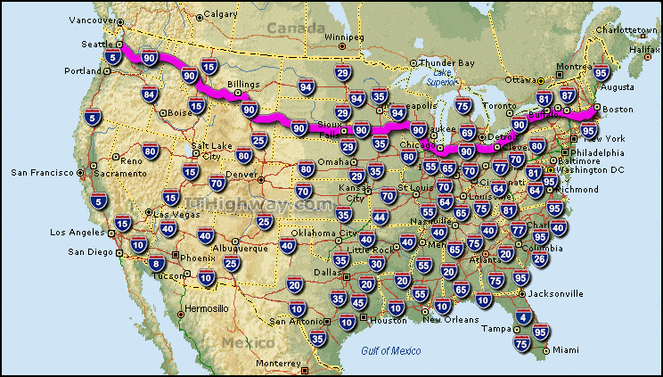
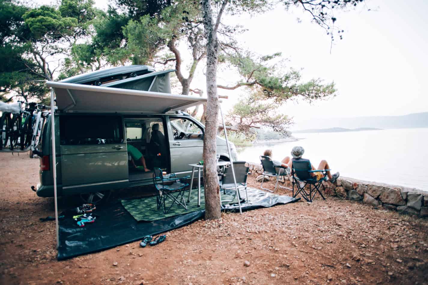
Sometimes the best RV vacations don’t have a specific destination. Driving down a highway of your choice to see what’s out there can be just as exciting. If you want a road trip RV vacation with everything for everybody, consider the longest highway in America: Interstate 90 – aka I-90.
In our discussion, we’ll discuss the history of our American Interstate system, the history of I-90, what to expect from the toll roads, and which rest areas or toll plazas you can boondock. You’ll also learn about the best roadside attractions along I-90.
The History of the Interstate Systems and I-90
In the summer of 1919, a Lieutenant Colonel participated in the first transcontinental motor convoy in United States History. Using the Lincoln Highway, the 81 motorized vehicles traveled 3,251 miles in 62 days. These newly developed cars and trucks fought mud, breakdowns, and the worst road conditions possible.

When that Lt. Colonel became the 34th United States President, Dwight D. Eisenhower remembered that grueling trip. As an American General in World War II and NATO General, he had experience moving troops around Europe quickly on the well-built roads that dated back to the Romans.
Ike knew that a sound highway system wasn’t just a civilian issue for commercial needs and quickly getting to point A to point B. It was a national defense concern. If the Soviet threat were to attack, moving military assets needed to be moved to position quickly.
President Eisenhower achieved his goal on June 29, 1956, when Congress approved the Federal Highway Act of 1956. It authorized 41,000 miles of an interstate highway network with roads that could support heavier weights, more direct travel for quicker travel, and higher speeds. The federal government would pay 90% of the costs of these expressways through a 3 cents per gallon gas tax (today, it’s 18.4 cents per gallon for unleaded and 24.4 cents for diesel).
Read more about other legislation that occurred right before this bill in our article on Motorized Vintage RVs.
Interstate 90 was one of the original expressways in the 1956 Act. It used highways that were either already open or were in the process of getting built. During this time, many of the eastern states were building new highways with tolls. These pay-as-you-go roads would fund themselves and other routes for maintenance and future expansion plans.
Eisenhower’s goal was to have freeways (non-tolled highways) instead of toll roads. In the give-and-take between the legislative and executive branches, the federal government would pay most of the bill to build the road, but it was up to the states to maintain them.
During the 1950s, as the Highway Act was solidifying, the states that sent in their requests for approval on toll roads had a good chance of support from the Federal Highway Administration. Many of the requests came from the eastern states. Road approval requests in the 1960s didn’t see many toll road requests.
If You Wanna Roll, Pay the Toll
The eastern half of I-90 is mostly a collection of toll roads. You’ll find them in:
- Massachusetts
- New York
- Ohio
- Indiana
- Illinois
Of the 3,020.44 miles that make up I-90, 1,046.12 miles exist as toll roads. For example, suppose you traveled from Logan International Airport in Boston, Massachusetts, heading west to the Wisconsin State line towing a single axle travel trailer (making you a 3 axle vehicle/medium truck). In that case, you’d pay $99.61 using an in-state electronic transponder or $122.26 using cash or the pay-by-plate billing method for all the tolls (as of August 1, 2021).
Since the toll roads were the foundation sections of I-90, the 1956 Federal Highway Act allowed the states to maintain the “rules of the road” before they became the cornerstones of the interstate. Pre- and post-World War II, these various toll roads were major arteries for these industrial states.
Selling bonds could only do so much to generate enough money for the construction and maintenance of these vital roads. The state governments needed a way to keep the money flowing into the road’s accounts to keep them going. So Ike’s Highway Act and a few minor bills beforehand introduced a gas tax to maintain roadways.
Even after the gas tax, the tolls for highways that see high volumes separate their costs from the surface streets. Therefore Main Street doesn’t suffer because the Turnpike has enough potholes to film a Moon Movie.
Toll Plazas
In the last 20-30 years, the rest areas on the toll roads have stepped up their game. Most toll plazas are now privately owned. You’ll now find fast-food chains, stores, and restrooms. You’ll find regular and diesel at the fuel pump, and most of them even have EV charging stations. (We recommend looking up the toll plazas individually to know which ones don’t have the rapid chargers.)
You can also charge yourself up with your favorite double half-caf, dry cappuccino with three-quarters skim, and 3 ¼ pumps of hazelnut, but don’t forget the spoon and a half of mocha sprinkles on light whip-double cupped and capped (we bet you can’t guess what this author did as his college job).
Before you leave the toll plaza, check out the pamphlets before you hit the road. You’ll find all the best and local roadside attractions as you cruise down I-90. Remember, driving through a state doesn’t count on your RV sticker map.
Best Toll Devices
You’ll find that most of the turnpikes are cashless. The state of New York removed the last of its toll booths in 2020. It’s now done through electronic readers if you have a transponder or high-speed cameras that capture an image of your windshield and your rear license plate. If you don’t have a transponder, the state uses those images to tally up all of the toll amounts you owe. They’ll either send you a bill in the mail or expect you to pay it within a certain amount of days online.
If you don’t satisfy this pay-by-plate (a.k.a. bill-by-plate) payment by a specific time, they have the right to tack on late penalty fees that could end up becoming more than the initial toll itself. You know how they say don’t mess with Uncle Sam; don’t mess with Aunt State either.
As RVers, some universal transponders on the market work with the different state transponder systems. Each one has its pros and cons. Some states play nicely with them, and others do not.
For example, The state of New York has a 3-tier toll payment system. If you use their E-ZPass and are a state resident, you pay the lowest price per toll. E-ZPass holders and universal transponder users not from New York pay at the second tier. If you don’t have an electric transponder at all, you pay the highest toll costs when you receive your invoice in the mail.
Every veteran RVer knows there’s no such thing as too much information when it comes to traveling. Tolls affect travel costs, just like fuel, road food, overnight campgrounds, tourist attractions, and other costs associated with the journey.
Interstate 90’s History and Travel Guide by State
To help you plan your road trip across America’s longest Interstate, we’ve broken I-90 down by state. The initial information is mostly self-explanatory. As an added advantage, we’ve linked the toll road website to help you calculate costs. The prices we point out show you how much you’d pay if you travel the entire turnpike using an electric transponder or if you’re paying cash towing an RV.
Massachusetts
- Total Miles: 135.72
- Major Cities: Boston, Springfield, Worchester
- Average Gas Prices: AAA Gas Prices
- Towing Laws: Towing Laws By State
- Toll Plazas: 8
- Tolls: Massachusetts Turnpike 3 Axle E-ZPass/Universal Transponder, Pay-By-Plate. Cash option in some areas
- Exit at 1A/East Terminus of I-90 to New York State Thruway (138.1 miles)
History of I-90 in Massachusetts
In 1948, The Massachusetts Department of Public Works (MassDPW) wanted to construct a highway from Boston to the New York state line. It would serve the growing population moving into the western suburbs of Boston and ease traffic congestion. At first, approval for the Western Expressway built the original mainline from the state line to the Weston and Newton town limits.
The original Western Expressway brought the 6-lane highway (3 eastbound and 3 westbound) to the front door (the outer suburbs) but not into the city of Boston itself. Construction of the Western Expressway occurred between 1955-1957. The final 15 miles through the city happened a few miles at a time from the 1960s up until the “Big Dig” project that brought the Massachusetts Turnpike Logan International Airport in 2003.
Toll Plaza Boondocking: Yes
Massachusetts will let you stay overnight in the rest areas and toll plazas. However, a few have signs posted stating it’s not allowed, so look before you set your jacks down. The only significant regulation is that your car/truck/RV can’t be unattended for more than 30 minutes.
Best Attractions in Massachusetts
- Old Sturbridge Villiage- Sturbridge
- Six Flags New England- Agawam
- U.S.S. Constitution- Boston
- Whitehall State Park- Hopkinton
New York
- Total Miles: 385.48
- Major Cities: Buffalo/ Niagara Falls, Syracuse, Utica, Albany
- Average Gas Prices: AAA Gas Prices
- Towing Laws: Towing Laws By State
- Toll Plazas: 18/25
- Tolls: New York State Thruway 3 Axles NY E-ZPass, Non-NY E-ZPass/other transponders, Bill-By-Plate. No Cash Option
- Exit 61- Ripley to Exit B1 (around Exit 20)- Albany for I-90/US Route 9 (488.32 miles)
I-90 breaks off/joins the New York State Turnpike northwest of Albany. It creates a northern border around the city, then makes a broad arc southeast to the state border, picking up the Massachusetts Turnpike.
Otherwise, I-90 travels around the state’s northern regions, acting as the principal conduit for Syracuse, Rochester, and Buffalo. From the Pennsylvania border to Albany, the entire road is most of the New York State Turnpike.
History of I-90 in New York
In 1944, the New York Department of Public Works (NYDPW) received the nod from Governor Thomas E. Dewey to construct the New York State Thruway. From the start, the intention was to have a superhighway that ran as the state’s spine, connecting the major cities. The first handful of sections that preceded the 1946 ceremonial groundbreaking in Liverpool, NY, began as non-tolled freeways.
The sections of the New York State Thruway completed construction in this order:
- Rochester to Lowell- June 24, 1954: 115 miles
- Buffalo to Rochester- August 25, 1954: 63 miles
- Lowell to Westmoreland- September 20, 1954: 5 miles
- Westmoreland to Albany- October 26, 1954: 95 miles
- Pennsylvania State Line to Silver Creek- August 21, 1957: 41 miles
- Silver Creek to Buffalo- December 14, 1957: 29 miles
- Berkshire Spur- October 8, 1958: 18 miles
Yet, the overall plan was to have the thruway sustain itself through toll collection. By June 1954, the first 4 women and 136 men of the toll collection class completed the 2-week training program. Toll supervisor Jim Murphy was the first to collect a toll at 10:01 p.m. on June 24, 1954, after the Governor signaled the toll collectors to begin on the Rochester to Lowell stretch.
After the Berkshire Spur opened, it connected Massachusetts to the New York State Thruway at Albany. With Eisenhower’s Highway Program in the books for two years, the Spur became the non-tolled portion of I-90.
Today, you’ll notice that if you’re on the thruway, I-90 separates at Exit B1. This 20-mile extension was added in the mid-1970s and bypassed Albany to the north. The new roadway became I-90, uncrowning a 6.5-mile section of the Berkshire Spur from its federal designation.
Toll Plaza Boondocking: No
The State of New York only allows you to stay up to 3 hours in their rest areas and toll plazas. Camping, drinking, and open fires are prohibited. However, you are more than welcome to use the provided grills and fireplaces while you’re there for an extended leg stretching or impromptu cookout. Pets, make sure you keep your humans leashed and clean up after them; humans can be messy.
Best Roadside Attractions in New York
- Jell-O Gallery Museum- LeRoy
- Eternal Flame Falls- Orchard Park
- Niagara Falls– Niagara Falls
- Anchor Bar- Buffalo
Pennsylvania
- Total Miles: 46.40
- Major Cities: Erie
- Average Gas Prices: AAA Gas Prices
- Towing Laws: Towing Laws By State
- Rest Areas: 2
- Tolls: No
History of I-90 in Pennsylvania
Have you ever been stuck between 2 decision-making authorities and end up compromising to make them both happy? That’s the story of the 46 miles of I-90 in Pennsylvania. Originally, Pennsylvania wanted to include I-90 in their turnpike system according to their 1956 plans. Yet, a year or two later, I-90 ended up becoming a freeway instead of a toll road.
When the plans and reports went to the federal government, at this point, they were looking to fulfill Ike’s Highway System plans. Also, New York already had its border connection complete back in ‘57, and Ohio had an expected border section opening date around 1960. By 1958, the Keystone State had about 2 years to pave the entire length. So even though Pennsylvania lost out on turnpike income on Interstate 90, they did make great strides on the I-76 corridor.
Boondocking in Rest Areas: No
Pennsylvania has a 2-hour limit for their rest areas and toll plazas throughout the state. The state will tow your vehicle if it hasn’t moved from the same spot for more than 24 hours on their toll roads. The law says nothing about the freeways (I-90 isn’t a toll road in Pennsylvania).
Best Roadside Attractions in Pennsylvania
- Presque Isle State Park- Erie
- Waldameer & Water World- Erie
- Presque Isle Downs and Casino- Erie
- UPMC Park- Minor League Baseball- Erie
Ohio
- Total Miles: 244.75
- Major Cities: Toledo, Cleveland
- Average Gas Prices: AAA Gas Prices
- Towing Laws: Towing Laws By State
- Tolls: Ohio Turnpike: 3 Axle E-ZPass, Cash
- Exit 2-Indiana State Line to Exit 142- Lorain County West/I-90 (142.8 miles)
History of I-90 in Ohio
On October 27, 1952, construction began on the Ohio Turnpike. The 241-mile highway finished construction in 38 months (although Ohioans know only 2 seasons: winter and orange cone season).
I-90 merges with I-80 on the westside of Cleveland. From the Pennsylvania Border, I-90 overlaps the old Northwest Freeway. Once I-90 connects with State Route 2 on the east side of downtown Cleveland, you’re going to see a lot of hazard lights warning you to slow down to 35 mph. The almost 90° turn is known as “Dead Man’s Curve.” It’s one of the most dangerous parts of the highway.
Experiencing Dead Man’s Curve ourselves, there’s nothing wrong with slowing down to 25 mph. Due to the high accident rate in 1959, this curve was one of the many measures to get drivers to slow down when driving through Cleveland (we won’t tell you the collisions reported yearly at Dead Man’s Curve).
The Cleveland Innerbelt Project replaced the 1959 bridge across the Cuyahoga River. The George V. Voinovich Bridge’s westbound side began in May 2011 and finished in November 2013. The eastbound side opened on September 24, 2016. Restriping and all 5 lanes became available on October 28, 2016.
Boondocking in Rest Areas and Toll Plazas: Yes
Ohio allows you to stay overnight in their rest areas and toll plazas, but there is a long list of prohibited behaviors. These behaviors include drinking, littering, camping, and lewd acts (yes, they list it). Unpermitted things like sales, advertising, or dispensing free coffee to drivers will also get you in trouble.
If you are going to boondock, stay on the pavement, keep 15-feet between the next RV, and keep the outdoor furniture stowed. Ohio doesn’t allow holding tank dumping at any of their plazas or rest areas.
Best Attractions in Ohio
- Cedar Point Amusement Park- Sandusky
- Mud Hens Minor League Baseball- Toledo
- Rock and Roll Hall of Fame- Cleveland
- Cuyahoga Valley National Park- Brecksville
Indiana
- Total Miles: 156.28
- Major Cities: Gary, South Bend, Elkhart
- Average Gas Prices: AAA Gas Prices
- Towing Laws: Towing Laws By State
- Toll Plazas: 8
- Tolls: Indiana Toll Road 3 Axle E-ZPass/Universal Transponder, Cash
- Ohio Turnpike to Exit at Westpoint/Indianapolis Blvd/Chicago Skyway (156 miles)
Indiana’s Major Moves Law
The approval for the Indiana Toll Road came in 1951 and opened in 1956. Shortly after, it joined its counterparts in the I-90 family. In 2006, the same company that leased the Chicago Skyway leased Indiana’s Toll Road for 75 years. Governor Mitch Daniels worked with the private company, ITR Concession Company LLC (ITRCC), and the State House of Representatives approved the deal on February 1, 2006.
Indiana used its share of the revenue to complete other highway projects in the state, while ITRCC maintained the Toll Road and its interests. Unfortunately, on September 22, 2014, ITRCC filed Chapter 11 bankruptcy and had to sell the lease that still had 66 years left. The new company, IFM, announced plans for improvements starting in 2020.
Boondocking at Rest Areas and Toll Plazas: Yes
Like Ohio, Indiana doesn’t have an official time limit but an expectation of fewer than 24 hours. There is a picnic area to relax and grill up some barbecue, but don’t confuse the plazas and rest areas for campgrounds because this isn’t the place to fully set up. You’ll find 4 toll plazas eastbound and 4 westbound.
Best Roadside Attractions in Indiana
- RV Hall of Fame– Elkhart
- University of Notre Dame- South Bend
- Indiana Dunes National Park- Chesterton
- Hall of Heroes Superhero Museum- Elkhart
Illinois
- Total Miles: 123.89
- Major Cities: Rockford, Chicago
- Average Gas Prices: AAA Gas Prices
- Towing Laws: Towing Laws By State
- Rest Area: 1
- Tolls: Jane Addams Memorial Tollway 3 Axle/Medium Truck I-Pass, Pay-By-Plate. No Cash Option
- Exit at Kennedy Expressway to Wisconsin State Line (79.2 Miles)
History of I-90 in Illinois
Interstate 90 comprises the Jane Addams Tollway (a.k.a. Northwest Tollway), the John F. Kennedy Expressway (non-toll), the Chicago Skyway Toll Road, and freeway areas in between. The original construction took place in the 1950s.
The Northwest Tollway was the first to open in 1958. The section we know as the Kennedy Expressway opened in 1960 but didn’t have a name until November 29, 1963. The section was named after JFK a week after our national tragedy in Dallas, Texas.
The section of I-90 south of Chicago was the last to open in 1962. It would be titled the “South Expressway,” but the former Cook County Board of Commissioner’s President, Dan Ryan, passed away in 1961. His zeal for these highway projects was a significant factor in getting them completed. The Dan Ryan Expressway is the given name for I-94, but it does merge with a section of I-90.
Continuing Jane Addam’s Legacy of Saving Lives
Jane Addams is a Chicago hero who won the Nobel Peace Prize in 1931 for her work with children, women, the NAACP, the ACLU, Hull House, adult education, and the list goes on. Rather than follow the traditional expectations of an affluent Euro-American of marriage and children, she broke through the social barriers of her era to advance the lives of others.
The Jane Addams Tollroad, west of Chicago, went through a Congestion-Relief Program from 2007- 2010. The goal was to widen the section where I-90 and I-39 are conjoined. The Illinois DOT redesigned ramps and toll booths, making off and on-ramps better suited for the heavy traffic they handle daily. Doing this lessened the bottleneck effect that creates heavy traffic congestion.
The Chicago Skyway Bridge
The Chicago Skyway Bridge opened in April of 1958 and connected I-90 to the Dan Ryan Expressway (I-94). At first, it only carried light traffic. Once the casinos in Indiana’s northwest region drew people, the Skyway needed reconstruction to handle the traffic. Also, The Skyway never incorporated the stretch of road into the Interstate Highway System.
From 1999 to the end of 2004, the State widened the deck, ramps, and roadway to modern-day standards. Since the road still exists outside of the federal jurisdiction, Chicago’s City Council voted to lease the Skyway to a private company for 99 years. The city provides police protection, but the company can collect tolls for operational costs, repairs, and a reasonable profit margin. The agreement was the first of its kind and continues today.
Boondocking at Rest Area and Toll Plazas: Maybe
Officially, you can stay at an Illinois rest area for 3 hours. However, you may see a sign that says, “After 11 Hrs Driving, You Need 10 Hours Rest”. The interpretation of this suggests you can stay overnight. We haven’t found Illinois’ official definition of this sign, so we won’t recommend staying overnight or not. All we will say is to use your best judgment, stay safe on the road, and cooperate with law enforcement if approached.
The only rest area you’ll find in Illinois is at Mile Post 2, coming into the state from Wisconsin. Otherwise, you’ll have to exit the highway if you need to refuel/recharge or need any other essentials while driving the 124 miles.
Best Roadside Attractions in Illinois
- Grant Park & Museum Campus- Chicago
- Medieval Times Dinner & Tournament- Schaumburg
- Midway Village Museum- Rockford
- Rock Cut State Park- Loves Park
Wisconsin
- Total Miles: 187.13
- Major Cities: Madison
- Average Gas Prices: AAA Gas Prices
- Towing Laws: Towing Laws By State
- Rest Areas: 8
- Tolls: No
History of I-90 in Wisconsin
Wisconsin opened its doors to I-90 travelers in 1967. The biggest challenge was the Dresbach Bridge that spans 2,497 feet across the mighty Mississippi. By 2016, the bridge’s replacement increased to 2,593 feet, used concrete box girders, and had separate bridges for each direction of traffic. Eastbound opened in November of 2015, and westbound followed in the summer of 2016.
You need to pay attention in Wisconsin because I-94 and I-39 merge into I-90 and later separate. So even with your RV LIFE Trip Wizard Pro Suite GPS, you’ll want to make sure you’re in the correct lane of traffic, so you don’t end up on the wrong highway.
Boondocking in Rest Areas: Yes
Wisconsin allows people to stay up to 24 hours at its rest areas. After that, you fall into the “long-term” category, which they don’t allow. You won’t find the rest areas as fancy as the toll plazas, but America’s Dairyland has a few tricks up its sleeves. Each of the 28 locations around the state memorializes a significant piece of the state’s history on a plaque that’s worth taking a few minutes to read.
For example, the state opened rest area 11 in Portage in 2010. The design of the facilities building uses Frank Lloyd Wright’s Prairie Style. The historical marker at this location is titled “Rest Areas On The I-Roads.” I-Roads refers to interstates.
Best Roadside Attractions in Wisconsin
- Koshkonong Wildlife Area & Jellystone Park- Fort Atkinson
- The Water Park Capital of the World– Wisconsin Dells
- Frank Lloyd Wright’s Winter Home– Spring Green
- World’s Largest Six Pack– LaCrosse
Minnesota
- Total Miles: 275.70
- Major Cities: Rochester
- Average Gas Prices: AAA Gas Prices
- Towing Laws: Towing Laws By State
- Rest Areas: 13
- Tolls: No
History of I-90 in Minnesota
Minnesota’s Interstate 90 history started with the Austin BeltLine. This 2.4-mile section bypassed Austin and was up and running by the Summer of 1958. The State’s DOT internal cataloging system initially labeled it as Highway 252 and Interstate Freeway 391. By the spring of 1963, there were only less than 9-miles of I-90 left to pave. The Blue Earth-Faribault County piece was the last section to open the whole highway in 1978. If you stop at the rest area near Blue Earth, you can read the plaque that discusses it in detail.
Boondocking at Rest Areas: No
Don’t set your jacks down in Minnesota rest areas. You only have 4 hours to refresh yourself, raid the vending machines, and enjoy the grounds. Interstate 90 is close to Minnesota’s southern border, so none of the rest areas close in the winter. You can use the Minnesota DOT 511 website for specific information or download their app from your mobile device’s app store.
Best Roadside Attractions in Minnesota
- SPAM Museum– Austin
- Jolly Green Giant Statue- Blue Earth
South Dakota
- Total Miles: 412.76
- Major Cities: Rapid City, Sioux Falls,
- Average Gas Prices: AAA Gas Prices
- Towing Laws: Towing Laws By State
- Rest Areas: 16
- Tolls: No
South Dakota: The Most Expensive Mile of Interstate 90
The Missouri River spans nearly a mile in width at the point I-90 needed to cross. Creating a causeway reduced the overall costs by more than half of what a bridge would be. It came out to be the most expensive mile for South Dakota but the least expensive water crossing for the entire I-90 Highway System.
Making I-90 Safer in the Mount Rushmore State
In 2009, the state’s DOT straightened the S-curve, reworked accident-prone interchanges, and removed left-side exits. They also added a trumpet interchange (the exit ramps for both directions make a trumpet bell shape between them), making it easier to connect to I-190. The exit to Ellsworth Air Force Base was reworked, reducing its high collision rate.
Boondocking at Rest Areas: Yes
South Dakota loves their RVers. Boondocking not only is allowed, but 4 of the rest areas you’ll encounter also have RV dump stations.
- Eastbound:
- Vivian- Mile Marker 218
- White Lake- Mile Marker 301
- Westbound:
- Vivian- Mile Marker 221
- White Lake- Mile Marker 301
After using their well-maintained facilities, check out the visitor center if you pull in during the day. There may be someone on staff to answer your questions and point out some great detour destinations along the way.
Best Roadside Attractions in South Dakota
- Sturgis Motorcycle Rally– Sturgis
- Wall Drug Store– Wall
- Mount Rushmore National Memorial
- Corn Palace- Mitchell
Wyoming
- Total Miles: 208.80
- Major Cities: Buffalo
- Average Gas Prices: AAA Gas Prices
- Towing Laws: Towing Laws By State
- Rest Areas: 5
- Tolls: No
History of I-90 in Wyoming
Interstate 90 is the youngest of highways in the Cowboy State (also known as the Equality State). The last section to open was the western-most section that connects Montana to Ranchester (July 8, 1985). Most of the interstate parallelled state routes and were used as I-90 until most sections existed separately in the mid-1970s.
Boondocking at Rest Areas: Yes
Wyoming has all but rolled out the red carpet for RVers at their rest areas. The Sheridan Rest Area at Mile Marker 336 is the only location you’ll come across with RV dump station services. The other 4 offer information centers, pet areas, and other features.
Boondocking within 24 hours won’t be a problem, but the state prefers if you keep the slideouts in travel mode rather than extended. In their brochure, which you’ll find in the facility, they mention there are over 175 campgrounds in the state that are better suited to your camping needs.
Best Roadside Attractions in Wyoming
- Yellowstone National Park
- Devils Tower National Monument
- Connor Battlefield Historic Site- Ranchester
- Keyhole State Park
Montana
- Total Miles: 551.68
- Major Cities: Billings, Helena Bozeman, Butte, Missoula
- Average Gas Prices: AAA Gas Prices
- Towing Laws: Towing Laws By State
- Rest Areas: 12
- Tolls: No
History of I-90 in Montana
Construction of Interstate 90 in Montana went smoothly. The Homestate Pass section began in 1964. Whitehall to Butte was the last section that finished up in 1966. In 1985 and 1987, there were some rebuilding and widening projects; otherwise, the Big Sky State gives you a wonderfully scenic drive.
Boondocking at Rest Areas: Yes
When you’re in the Big Sky Country, it’s going to take you a while to look around. You may even need to sit a spell to contemplate the scenic majesty of the Montana landscape. So don’t rush yourself or your family in their rest areas; you have 24 hours to take your boots off.
Best Roadside Attractions in Montana
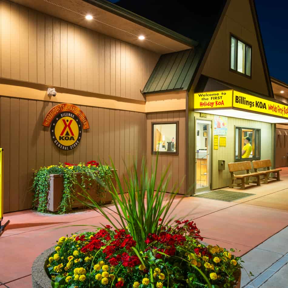
- Custer’s Last Stand & Billings– Billings
- The First KOA– Billings
- Our Lady of the Rockies- Butte
- Old Prison Museum- Deer Lodge
Idaho
- Total Miles: 73.55
- Major Cities: Coeur d’Alene
- Average Gas Prices: AAA Gas Prices
- Towing Laws: Towing Laws By State
- Rest Area: 1
- Tolls: No
History of I-90 in Idaho
Idaho’s first offering to Interstate 90 was the Coeur d’Alene Belt Route that circled the edge of town in 1960. The connection to Washington followed in 1970 with an update in 1976. In recent years, the Veterans Memorial Centennial Bridge opened on the east side of Coeur d’Alene in 1992. It replaced an older section along the Lake that share’s the cities name. The old section is still accessible for hikers and bikers as a trail. If you use the Potlach Hill Road overpass, you’re traveling on the original I-90.
The Last Traffic Light of I-90
If you check the National Register of Historic Places in 1976, you’ll see a little town in Idaho named Wallace. The Idaho section of Interstate 90 was one of the last opened. The original plan cut straight through Wallace, but the town council and its people found a way to keep their homes. By having their town placed on the National Registry as the last traffic signal bypassed by I-90, the city became a national landmark that had to be protected.
As a result, the final routing of I-90 runs north of Wallace on an elevated roadway that finished on September 12, 1991. The road that runs through the town, U.S. Route 10, was renamed Business Loop I-90. After the concrete and road stripes dried, the city retired the signal.
Boondocking at Rest Areas: Yes, but…
Idaho has 2 rest areas 8 miles from the Washington state line. The Huetter Rest Areas (east and westbound) offers a bike path, vending, basic facilities, and wifi. You can stay 8 hours on interstate rest areas but 16 hours on U.S. and state routes within the borders of Idaho.
Best Roadside Attractions in Idaho
- Oasis Bordello Museum- Wallace
- Heyburn State Park– Coeur d-Alene
- Silverwood Theme Park– Athol
- Crystal Gold Mine- Kellog
Washington
- Total Miles: 296.92
- Major Cities: Seattle and Spokane
- Average Gas Prices: AAA Gas Prices
- Towing Laws: Towing Laws By State
- Rest Areas: 10
- Tolls: No
History of I-90 in Washington
The Ellensburg to Vantage section of Interstate 90 opened on November 20, 1968. The Lacey V. Murrow Floating Bridge was the last project to open Washington from Seattle to Spokane. In 1996, a $1.56 billion project adapted the interstate with adjacent trails. Construction included widening tunnels, restructuring retaining walls, and adding walking space on bridges. There was also a 1993 project that replaced a 1940 floating bridge due to it partially sinking from a 1990 storm.
Making Snoqualmie Pass Safe for Wheeled and Paw Traffic
Washington’s DOT started a multi-phase project on the 15-miles of the Snoqualmie Pass stretch of Interstate 90. The pass is known for avalanches and rock slides making it another dangerous zone on the highway.
- Phase 1: 5-miles between Hyak and Keechelus Dam– Widen I-90 and the bridges with new avalanche-safe versions. The mountain slopes were stabilized, and other safety measures were set in place. Construction finished in 2018.
- Phase 2: 2-miles between Keechelus Dam to Stampede Pass interchange– The state used the money saved from Phase 1 to build the first Wildlife Overpass. How did the deer cross the highway? She used the overpass safely instead of dodging cars and trucks. Construction finished in 2019.
- Phase 3.1- 3.3: The last 8-miles from Stampede Pass interchange to Easton– The DOT broke the remaining length of the project into 3 sub-phases. These sections will widen from 4 lanes (2 EB & 2 WB) to 6 lanes. The Washington DOT will address other wildlife crossing and mountain dangers as well. The orange cones will disappear by 2029.
Boondocking at Rest Areas: Yes, but…
The State of Washington’s rest areas can deceive you. At first glance, they look like any other rest area built in the 1970s or 1980s. On Interstate 90, the Indian John Hill locations on both sides of the highway have RV dump stations (mile marker 89). The same is true for the Winchester rest area at mile marker 161. Schrag westbound and Sprague Lake eastbound have dumping stations for RVs, but the State’s DOT closes them during the winter due to freezing temperatures.
If you need to stop due to lack of energy, Washington gives you 8 hours at the rest areas. You can sleep in your car or RV without penalty. Remember, RV heroes live to drive another day.
Best Roadside Attractions in Washington
- Gingko Petrified Forest State Park- Vantage
- Snoqualmie Falls National Forest
- Pike Place Market- Seattle
- Museum of Pop Culture- Seattle
Where to Now?
A trip like this can take you anywhere between a week (stopping only a few times) up to a month at a meandering pace. If you enjoy the journey more than the destination, you may want to spend some time in Washington’s Olympic Penninsula to get your strength back (we recommend the Sol Duc Natural Hot Springs. It just so happens that nature provides a “hot tub” at the end of your journey. So why not set up at the nearby campground and ease up those muscles.
When you’re ready to hit the road, there are several roads you could travel:
- The Alaska-Canada (AlCan) Highway- If it’s the right time of year, you could head up north to Alaska.
- U.S. Highway 101- Take a cruise on the Pacific Highway, enjoying everything the coast has to offer.
- Interstate 5- Make your way through the mountains to California and beyond.
- Stick around and explore the Cascade Mountains and British Columbia.
- Choose your own adventure using the best trip planner: RV LIFE Trip Wizard.
Thanks for reading; we’ll see you down the road!

Great article Brian!
I will avoid all toll roads in the interstate system. These states that use them as toll roads are bilking drivers out of billions of dollars if a state can cover the cost of rebuilding the roads on the fuel tax alone then the rest could also. They are simply using it as a cash cow at public expense
Hopefully the income from tolls goes to good use!
we have a 40 ft diesel pusher with 2 axles do we have to pay toll fees.
Hi Maegaret, you’ll have to check the requirements for each section or state. But I would assume yes.
Maegaret:
That’s a great question. If you go to each state’s Department of Transportation (DOT) website, you’ll see that they charge by how many total axles you have on the ground. For trucks that have 2 axles, but have extreme weights well beyond what most Prevost motorhomes weigh, there is an extra cost. My best answer is always to check with the State’s DOT, but I will safely say, don’t expect to pay anything obscene.
Please spell “Niagara” correctly!
Good catch Joel!
That’s Niagara, not Niagara.
Thanks!
I really have to agree with Dave Robinson. When I was stationed at the Sub Base in New London, CT, in the 1970s and traveled I-95 between patrols to visit family, I truly could not understand how the state of Connecticut could actually charge tolls on I-95 just by labelling it The Connecticut Turnpike!
Every 1.5 miles or so, you had to stop at a toll booth and pay either $0.25 or $0.35 in order to drive on an Interstate highway with potholes large enough to swallow a Volkswagen!! None of the toll money appeared to go towards repairs of this highway for the 5-6 years I was stationed there!
We drove back up there approximately 25 years later (I don’t remember the reason). I had been retired from the service for some time by then. All of the toll booths had been removed. The road was still in the same state of disrepair as the last time I had driven on it, with a few ill-performed patch jobs performed here and there.
How can these states justify charging anyone to drive on Interstate Highways when they don’t use the monies received from these tolls, plus the Federal funds received, to repair these vital transportation throughways?
We took I-90 4 or 5 years ago. It was the worst and most expensive road we’ve ever been on. An RV with a toad was around $150 in tolls. I’ll never use it again.
Oh no! Thanks for sharing.