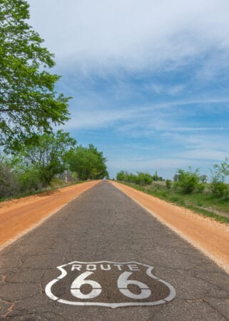
Quick, what’s the most famous American road that pops into your mind? What’s the first answer in your mind without thinking about it? Is it U.S. Highway 101 that takes you up the Pacific Coast? How about U.S. Highway 1 that goes from Maine to the Florida Keys? Could it be that interstate bypass that’s just as congested as the main highway on your daily commute (although nobody wants to think about that one)? If you’re an RVer, your answer may be U.S. Highway 66, also known as Route 66. There’s no other road that symbolizes America and its heritage than this iconic highway. We’ll show you the history under the pavement, how the Main Street of America gained fame throughout time, the innovations the Mother Road gave birth to, and who Route 66 calls “Papa.”
From Trails to Foundations
Suppose you page through a history book that focuses on early civilizations. In that case, you’ll find that human beings generally settled in two places: either next to water or critical points on significant trails. In the United States, the Cumberland Pass, Ozark Trail, Santa Fe Trail, and Old Indan Trace are just a few of the paths that bore today’s cities.
When we fast forward to the age of the railroad, around the time of the U.S. Civil War, Congress sent Army officers to map out a route for the transcontinental railroad. Lt. Edward Fitzgerald Beale created a passage from the Pacific to Fort Smith, Arkansas, making a road for migrants and gold rush miners on their way to California. This road led to creating towns named Albuquerque, Barstow, Flagstaff, and Gallup (you might have heard these city names before).

By the end of the 19th century, these trails became dirt roads people would travel on either on horseback, horse-drawn wagon or walk. Farmers would take their produce to the closest city to sell their produce, which wholesalers would then send via locomotive to the east or west.
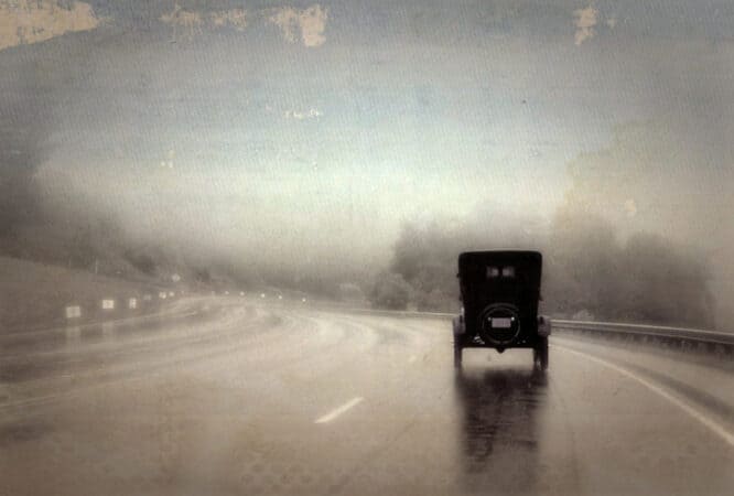
When Henry Ford made the automobile affordable for almost everyone in 1908, the nature of travel changed. People wanted to take their cars out for a drive. By 1910, the RV Antique Era (1910-1944) began. People were hitching up their tent campers and other RV towables. Trails like Beales and others were the closest thing to highways at the time, and they made horseless carriage rides a bone-shaking experience.
National Old Trails Movement
The National Old Trails Movement (N.O.T.) lobbied the federal government for a paved transcontinental roadway that linked existing trails and roads. The plan they submitted to Congress in 1912 mapped out a route that ran from San Diego, California, to Washington D.C. Since the east had good roads, the plan finished the trip using the existing paved road from Washington to Baltimore, Maryland.
The lobby group’s name had a purpose. Their proposed roadway followed famous historic trails used for the country’s expansion. The Cumberland Road linked Washington D.C. to St. Louis, Missouri. From St.Louis to Alburquerque, New Mexico, the pavement would lay on top of the Sante Fe Trail initially established by the Spanish Colonies in the 1700s to the Pacific Coast. The original 1926 Route 66 road takes advantage of the N.O.T. plan from Romeroville to Alburquerque, New Mexico, and then to Los Angeles, California.
Ozark Trail Association
Teacher, entrepreneur, and travel enthusiast William Hope “Coin” Harvey established the Ozark Trail Association in 1913. His association promoted good roads, road signs, and well-drawn maps, enhancing the drive across the United States. His organization created a trail of existing roads that ran through Missouri, Oklahoma, Texas, and Eastern New Mexico. To a tourist, road signs were rare, and one dirt road was indistinguishable from the next. Coin set up two four-sided pyramid monoliths at critical junctions. They were 50-feet tall, and each side gave the distance of significant cities if you went a certain way.
For example, if you looked at one side, the top would have an arrow pointing to the right and a list of cities below it with the distances from that point. So you would read this as, “If you turn right, here are the cities you’ll reach, and this is the distance to each city from this point.” Between Stroud and Davenport, Oklahoma, you can still see one of these monoliths. Government officials removed the second one in 1920, but it stood in Romeroville, New Mexico. You can see the second one at the junction of the N.O.T. and Ozark Trail. Today that translates to the corner of US-85 and US-84.
The Federal-Aid Highway Act of 1921
As millions of Americans traded in their horse and wagons for automobiles, Congress and political lobbies focused on the conditions of roads. Cars during this time ran well on paved and summertime dirt roads. When it came to mud or snow, drivers lost a lot of time digging their cars out. By 1912, organizations like the American Automobile Association (AAA) and other groups wanted the federal government to do something about it.
The Lincoln Highway
When Woodrow Wilson passed his Federal Highway Act in 1913, it gave federal and state money for road building, maintenance, and road signs. The first coast-to-coast highway was dedicated and started its 3,000-mile construction plan. The Lincoln Highway (now U.S. Highway 30) began in Times Square, New York City, New York, and ended in Lincoln Park, San Francisco, California.
Most of it remained as a dirt road, but there was enough money to pave certain sections. Newspaper journalists gave one section in Indiana the title, the “ideal section.” The 1.3-mile stretch used steel rebar to reinforce 10-inches of concrete. The road’s surface had a crowned shape and side gutters to remove water. This building technique became the model of how road builders would build all roads from that point on. Among the states, there were still a lot of unresolved issues. An example is some would stop paving a road a few feet from the state border. Yes, this did happen because “those Lilly-Livered [insert neighboring state’s name here] can spend the money, not us.”
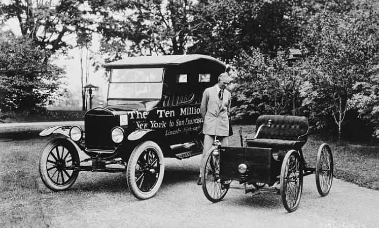
To counteract issues like this, President Warren G. Harding signed into law the 1921 Federal Highway Act. The law required states to meet a set of requirements to receive federal funding for road projects (in other words, behave yourselves, or Uncle Sam’s not helping). It also standardized road measurements like paved road widths had to be at least 18-inches. The government expanded the Federal-Aid Highway Act in 1925, creating a U.S. highway (also known as Routes). However, it would be another 30 years before we would “like Ike” for his Interstate Highway System. Tulsa, Oklahoma Native Cyrus Avery (no direct relation to the label system guy), a committee member responsible for designing the highway system, came up with the numbering system.
- Odd-numbered roads run North to South, starting with U.S. Highway 1 that runs along the Eastern Coastline and 91 (Utah to Idaho) out west. Later, the government updated the system to include highways 93-101.
- Even-numbered highways that run East to West started with the U.S. Highway 2 that runs along the Canadian Border and ends with U.S. Highway 90, which now crisscrosses with Interstate 10.
The Creation of U.S. Route 66
John Thomas Woodruff from Springfield, Missouri, was a promotor of the Ozark Highways and led the Inter-Ozarks Highway Association. He lobbied to have State Route 14 and Highway 5 intersect in Springfield. As a businessman, having these two major roads was like the state and federal government rolling out the red carpet to his business’ front door.
In 1926, Cyrus Avery and John Woodruff successfully lobbied to create U.S. Highway 66 through their U.S. Highway 66 Association. The Route started in Chicago, Illinois, and ended in Los Angeles, California. While he lost the battle for Route 14, 66 followed the same path, giving him a victory in the overall war. Avery also won since the new road would run through his hometown of Tulsa. The mining interests that backed the association were delighted with the stops in Joplin, MO, Galena, KS, and Miami, OK.
What’s the Right Number?
Now that U.S. Route 66 was approved, it was an anomaly according to Avery’s numbering system. It didn’t run coast-to-coast in the traditional sense. Half of it ran Northeast-to-Southwest while the other half had an East-to-West direction. The first thought was to call it Highway 60, but it didn’t run coast-to-coast. The government thought about 62. After some debate, Woodruff and Avery sent a telegram from Springfield, MO to Washington D.C. settling the matter:
“Regarding Chicago Los Angeles road if California Arizona New Mexico and Illinois accept sixty six instead of sixty we are inclined to agree to this change. We prefer sixty six to sixty two.”
Remember, punctuation back then cost extra with telegrams and was rarely used, except for periods. Telegraph operators sent all messages via morse code. The telephone did exist, but only in local areas. During this time, AT&T was developing radiotelephone technology and starting to string up transcontinental telephone lines. The telegram was still the affordable way to communicate with long-distance. In the end, it would be Avery, not Woodruff, who would receive the credit as the “The Father of Route 66.”
Constructing the Main Street of America
Route 66’s path was essentially already laid out. From 1926-1938 construction consisted of reconditioning county and state roads. The majority of the road had to be paved, except for 800 miles that had previous pavement. Road architects replaced road signs to update the new highway.
If you travel between Afton and Miami, Oklahoma, you’ll see a stretch of Route 66 that has the original pavement that pre-dates the 1926 pavement. The Ribbon Road (a.k.a. Sidewalk Road) measures only 9-feet wide and isn’t divided. The Ribbon Road dates back between 1919-1924. If it’s all clear, you can drive on the pavement, but if you see on-coming traffic, both of you have to drive on the gravel partially. There is a by-pass for those that need an alternative.
The Great Depression and Post World War II
During the Great Depression, many displaced workers believed the streets of California were paved with “milk and honey” as their forebearers thought about America when they immigrated from Europe. U.S. Highway 66 became the road of choice from St.Louis to L.A. When they reached the West Coast and saw how hard the Depression hit California, around 8% of them stuck around.
During this time, farming in the central states suffered from severe droughts during the 1930s. Dust storms so intense, they would blacken the sky destroyed good farmland. These “black blizzards” would fallow the ground to the point where farmers would lose their land to the bank. Part of President Franklin D. Roosevelt’s New Deal Program offered infrastructure jobs to displaced workers. A significant portion of those jobs was completing work on the new highways. As these workers completed Route 66, many family-owned businesses sprung up catering to the workers and travelers. With full crews working, Route 66 was fully paved and constructed by 1938.
The Mother Road Nickname: Truth, Bible, Communism, and The Nobel
John Steinbeck’s 1939 novel, “The Grapes of Wrath,” depicts a fictional family living through these actual events. Migrant workers loved the literary work because of its accuracy but banned it in libraries and schools during the “Red Scare” due to its perceived “Communist Propaganda” ideas. Ultimately, Steinbeck’s work received a final judgment in 1962 from the Committee in Stockholm when this novel won him the Nobel Prize for Literature.
In the 12th chapter of his book, Steinbeck’s characters believe Route 66 is the “Mother Road” that will lead them to a better future. With nothing but dust, fallow fields, and foreclosed property in Oklahoma, the characters have a hope that, like the Hebrews in the Book of Exodus of the Old Testament, California has everything they want and need.
U.S. Highway 66 Gets a Theme Song
Bobby Troup’s love of music and music composition started in college. When he joined The United States Marine Corps in 1941, he was one of two dozen white officers to direct African-American recruit training at Montford Point, a depot for a satellite of Camp Lejeune. Later he became the recreation officer for sports and created the first African-American band in the Marine Corps. His music and acting career would continue for most of his adult life.
In 1946, Bobby Troup and his wife Cynthia had to drive from Pennsylvania to Los Angeles. During the drive, Cynthia came up with the line, “Get Your Kicks On Route 66.” Inspired by his wife, Bobby spent the rest of the trip writing the lyrics and music. Once the couple reached Los Angeles, California, he performed the song for one of the hottest piano players known for his smooth voice.
Chicagoan Nat King Cole first recorded this iconic American classic song in the same year. Bing Crosby teamed up with the Andrew Sisters in ‘46 adding their vocal stylings to the song. Other noteworthy performances include:
- The Pied Pipers: 1946
- Perry Como: 1959
- Chuck Berry: 1961
- The Rolling Stones: 1964 (Based on Chuck Berry’s version)
- Asleep At The Wheel: 1976
- Manhattan Transfer: 1981
- Depeche Mode: 1987
- Michael Martin Murphey: 1989
- Brian Setzer Orchestra: 1994
- John Mayer: 2006 (for a CGI Disney Movie)
- Robin Williams, Jeff Daniels, and the Cast during the credits of a popular comedy movie, RV: 2006
- Glenn Frey of The Eagles: 2012
Route 66 Hits The Small Screen (Sorta)
In 1960, CBS created a vague spinoff of its crime drama “Naked City.” It featured two young men driving across America in their Chevrolet Corvette convertible, getting involved in crime mysteries wherever they stopped. The purpose of their journey was to find their purpose for life. The 116 episodes ran for 4-seasons in a weekly hour format starting October 7, 1960, and the series finale aired on March 20, 1964. Martin Milner starred throughout the show. George Maharis co-starred for the first three seasons, with Glenn Corbett replacing him for the last season.
Even though the show was titled “Route 66,” most of it took place throughout the United States, one episode in Toronto, Ontario, Canada, and another set in Mexico (although filming took place in California). Rather than pay Bobby Troup royalties, CBS commissioned one of their regular composers, Nelson Riddle, to score the theme song.
If you’re one of those fans that enjoy finding “Easter Eggs,” inconsistencies, or other goofs, yes, they did change the car throughout the seasons. The original pilot had the 1960 Corvette. However, from the second episode through the third season, it was the 1961 model. The final season started with the 1963 model year but replaced it with the 1964 vette halfway through (if you want any other verifications, we’re sure there are forums out there in cyberspace that can help you out).
The Children of the Mother Road
Cyrus Avery nicknamed Route 66 the “Main Street of America” for a few reasons. Many of the roads used ran through the main streets of existing cities and towns already in existence. As traffic increased, many businesses started to spring up along the route. New towns developed because of the high traffic and significant intersections. Many of today’s travel conveniences developed on Route 66. Entrepreneurs didn’t invent these new concepts, but many evolutions arose with the competition around the bend. Most of the ideas started on U.S. Highway 1 back east for travelers traveling from Miami to Washington D.C. or New York.
Motels and Travel Courts
At first, small single-room cabins clustered together were available for weary travelers to spend the night so that they could start fresh the next day. These motor courts were family-owned, except for the Ring Rest chain in the 1930s. Unfortunately, travelers had to be careful which motor court they stayed at because those up to no good would set up shop in these cabins. These travel courts and auto camps offered laundry facilities, showers, kitchen areas, and other amenities.
After World War II, motel brands like Howard Johnson (HoJo), Holiday Inn, and Best Western set the new standard for 1-2 night stays on U.S. Highway 66 and other roads. However, you can still find some early motels, like the Blue Swallow in Tucumcari, New Mexico, on the road today.
Motels offered safe and comfortable conditions. You could park your car in front of your room, sleep in clean bedding (remember this was the 1950s and 1960s), watch TV, have a private full bathroom, and enjoy the swimming pool. They were family-friendly, and if they didn’t have a diner inside the main office, there was a restaurant next door.
Campgrounds
For RVers, you could park at the travel courts during the Antique Era (1910-1944). After WWII, during the Vintage Era (1945-1970), campgrounds started to show up. At first, they were all primitive sites. As technology developed and owners ran plumbing and electric wiring to many campsites to stay ahead of the competition.
Service Stations
Today, when you fill up your gas tank, you can go inside the building to grab snacks, groceries, auto supplies, and other conveniences. Until the late 1980s, Gas stations had one or two repair bays with auto mechanics on staff to fix any problems you had with your vehicle. The service station concept developed on the Main Street of America. If your tire blew, your radiator overheated, windshield cracked, or something worse, the next town had a service station to fix the problem and fill up your gas tank to keep you going (and probably a Hershey Bar or two at the cash register).
Ike’s Highway System
In the final stages of Route 66’s construction in 1937, The decision-makers gave the western half of the road a straighter course, giving trucking a shorter distance to travel for shipping purposes bypassing portions of the Ozark Trail and the N.O.T. When Congress passed President Dwight Eisenhower’s Highway System legislation in 1956, it created our modern-day Interstate System. For more details, you can read more in our Vintage Era Motorized article.
The interstate system was the beginning of the end for Route 66 and high usage for the U.S. Highway System enacted by the 1921 Act. The western half of Route 66 (the 1937 version) became the skeleton for Interstate 40, but the eastern half and the towns on the Ozark and N.O.T. trails saw their economies dry up weeks after the interstates opened.
On June 27, 1985, the American Association of State Highway and Transportation Officials (AASHTO) voted to decertify U.S. Highway 66 and remove its road signs. This decision allowed the new suburban towns to disconnect the road and use it for their purposes. RV caravan clubs and Route 66 enthusiasts kept the Mother Road alive by tracking the various changes and creating maps. Some RV clubs would take annual caravan trips down the road.
Rehabilitating Momma
After the decommissioning, federal, state, private agencies, and private citizens realized the significance of Route 66. The U.S. Highway was a part of American History as our Civil War battlefields, National Parks, and other significant landmarks. Congress passed Public Law 101-400, the Route 66 Study Act of 1990. The Act recognizes how historically substantial the road is to American Heritage and tasked the National Park Service (NPS) to conduct a resource study to explore options for preserving, interpreting, and using the road for American History.
The study results led to Public Law 106-45, which created the Route 66 Corridor Preservation Program. The NPS has a library of resources and research devoted to the Main Street of America accessible to the public. It contains federal, state, and local records of the road and town documents. Newspapers and magazines have donated articles relating to the Mother Road too. People who’ve cleaned out their garages and attics donate family items that connect them to Route 66.
For many, they wanted to take it a step further. Organizations lobbied to turn Route 66 into a National Trail. The National Park Service already protects the Selma to Montgomery National Historic Trail, the Trail of Tears, and the Pony Express, to name a few of the 19 recognized trails. The National Trust for Historic Preservation is one of the organizations that worked on getting Route 66 on the NPS list of National Trails.
On September 17, 2020, Representatives introduced legislation to designate Route 66 as a National Historic Trail. On December 23, 2020, Congress completed the final passage of the Route 66 Centennial Commission Act. The announcement will happen on Route 66’s centennial anniversary on November 9, 2021. One hundred years after President Harding signed the 1921 Federal Highway Act.
We hope you enjoyed walking down memory lane with us. Luckily it wasn’t 2,400 miles long like Momma was. If you are planning on “Getting Your Kicks Down Route 66,” you may want to do it sooner than later. Once that announcement happens in November, the Main Street of America may look like Washington D.C.’s innerbelt, much like Zion National Park’s hiking trails.
If this is your first time learning with Camper Smarts, make sure you sign up to receive our weekly newsletter every Tuesday. You can also learn more from our affiliates on RV Life Magazine, Camper Report, RV LIFE Campgrounds, and Do-It-Yourself-RV. When you’re ready to “wind from Chicago to L.A.,” make sure, you’re all set with the RV Life Trip Wizard and the companion apps. It’ll keep you on course, help you find main courses, and find the best accommodations, of course.
We’ll See You Down The Road.
About The Author
Although he’s from Motown, Brian is a legacy RVer that grew up on I-75. He, his wife, and three working-class fur-babies have enjoyed the full-time RV lifestyle since 2017. Like John Madden, he hasn’t “worked” in years because he gets to write about his passion. When he’s not working, he supports his daughter’s dog rescue efforts and disability causes. Learn more with him on Camper Smarts.com


Really nice job. Thanks
. It also standardized road measurements like paved road widths had to be at least 18-inches.
Thanks for the egg !!!
Very informative article. Thanks for the history lesson. I’ve been wanting to travel Route 66 for awhile. After reading this it might be sooner not later. Thanks and looking forward to reading more articles.
I have lived full time in an RV since 1985. Bought my first desk top computer about 1991. Decided to drive old 66 from Joplin to Tulsa. The road was so rough I lost two databases on that road.
Don’t forget US 301, just as significant as US 1, maybe more.
Need a follow-up on Angel Delgadillo in Seligman, AZ , Guardian Angel of Route 66. History is not complete without him.
Blue Ridge Parkway followed immediately by Pacific Coast Highway popped into my mind. Before the long boring highways crossed the west, our family would travel along portions of Route 66 on our way east to visit relatives. While I care fond memories for much of that travel, none compared to the spectacular beauty of the Pacific Coast in my youth and the Blue Ridge with my own family.
I was 15 when my dad was offered a job in California just east of Los Angeles. He decided to take me with him, the year was 1959. We left Jersey City, New Jersey, drove for about 1 day (non stop) to Chicago, Illinois and picked up Route 66.
We drove for some time. My dad was starting to tire when he saw a hitch hiker and decided to pick him up. The first question was “Do you have a drivers license?” Yes was the answer. Another fortunate thing was that his destination was Los Angeles, California.
Including the day long drive to Chicago the trip lasted 4 days. Some of the road scenery is still in my mind. A trip I will never forget!
What a great article, thank you so much for the nostalgia. Haven traveled this historic road many times as a military family and then fulltime RV’ers, this brought back wonderful memories. I kept hoping you would include a line about quirky Oatman, AZ with its unique western character and sweet donkeys roaming the streets. Can’t wait to read more of your thoughts and adventures.
Had the absolute thrill of a lifetime exactly 53 years ago last month when I drove much of then still in existence Route 66 from Long Beach CA to St Louis. Sorry had to branch off there as I was headed to the east coast. All this was in my 67 VW Beetle complete with the sliding sun roof. Got to experience the Mojave Desert at night too. Still recall the trucks way off in the distance as I got ever closer and who could forget the mock oil derrick towers of the Whitings Gas Stations across AZ and NM.
Dick P – Orrington, Maine