The National Park Service manages 423 sites. Many are historical sites and monuments, but 63 are full-fledged national parks. California has more national parks than any other state. Several are excellent for winter camping or saving money during the National Park Fee Free Days that occur later in 2022. Below you’ll find 4 California National Parks perfect for satisfying your winter camping cravings.
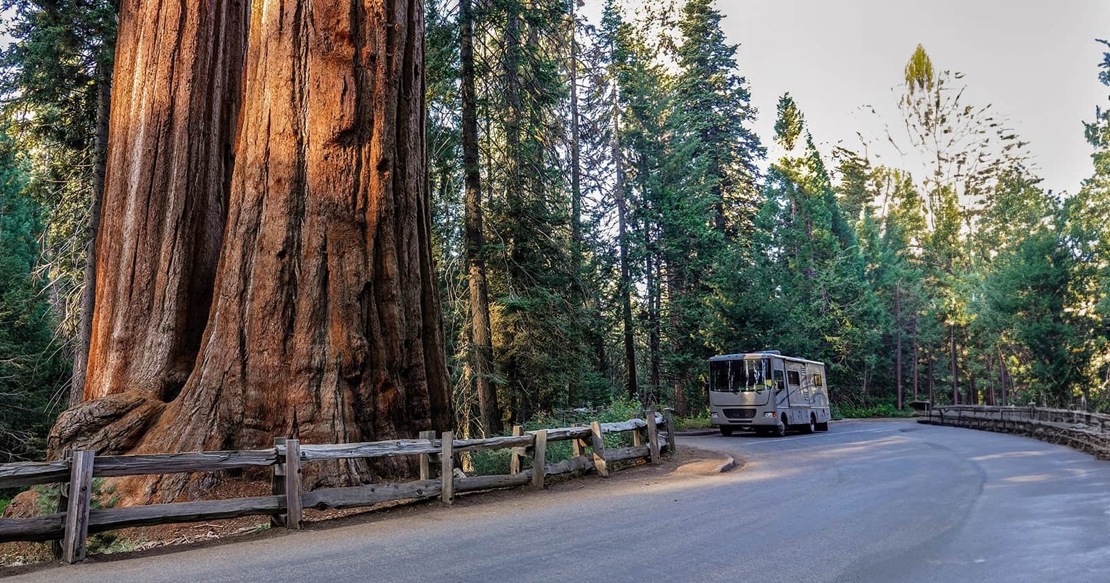
Pinnacles National Park
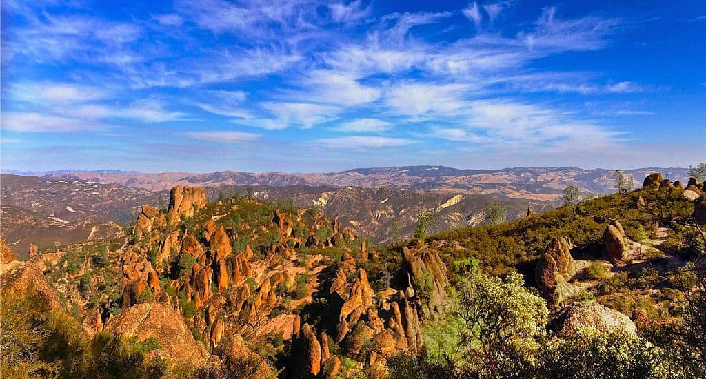
Previously a monument until Barack Obama redesignated it as National Park in 2013, Pinnacles National Park supports a diverse array of wildlife like canyon bats, mountain lions, and hummingbirds. It also hosts sensitive species you won’t find in many places elsewhere, such as the big-eared kangaroo rat, Gabilan slender salamander, Pinnacles shield-back katydid, Pinnacles riffle beetle, and condors.
“Some 23 million years ago multiple volcanoes erupted, flowed, and slid to form what would become Pinnacles National Park. What remains is a unique landscape. Travelers journey through chaparral, oak woodlands, and canyon bottoms. Hikers enter rare talus caves and emerge to towering rock spires teeming with life. – National Park Service

Winter Climate
While summer temperatures can reach the 90s, winters are mild, with day temperatures hovering between 60 and 65 degrees Fahrenheit and nights usually just above freezing. This smaller park can fill up quickly during the peak season, however, winters seem to see fewer crowds. The mild winters along with fewer people make this park an excellent winter camping choice.
Getting There
There is no road that goes from one side of the park to the other. Visitors must enter from either the East or the West. Because of the two separate entrances that are not connected, the National Park Service provides directions on their site but recommends plugging in the GPS coordinates of the entrance you intend to go to if using online maps or a GPS app.
For the East Side of Park (Pinnacles Visitor Center): 36.493545, -121.146646
For the West Side of Park (Pinnacles Visitor Contact Station): 36.477700, -121.226136
Hiking at Pinnacles National Park
There are more than 30 miles of trails in the park for many different skill levels. It also has a variety of rock climbing routes.
Bear Gulch Cave Trail
This trail is one of the most popular moderate trails in the park. It features varying terrain that includes wide flat trails, caves, and some steeper challenging areas as well. The trail is about 2 miles roundtrip from the Bear Gulch Nature Center or 3.5 miles roundtrip from the Manzanita Parking area.
Those wishing to explore the cave on this trail will need to bring a flashlight and make sure the cave is open. The park closes the caves mid-May through Mid-July while the protected colony of Townsend’s big-eared bats raise their young during this time. Another reason to pay this park a visit outside the summer months.
Old Pinnacles Trail
The 2 mile Old Pinnacles Trail offers flat gravel trails and bridge crossings with a moderate climb for those looking for an easier hike. Hikers will see several types of wildflowers as well as a couple of creeks. You can access the trail from the Old Pinnacles Parking Area. This out and back trail terminates at the junction of the Balconies Cliffs Trails or Balconies Cave Trail. Those wishing to extend their hike can choose to continue on to these more moderate hikes that reach the west end of the park.
Rock Climbing
For its smaller size, there are a lot of rock climbing opportunities in Pinnacles National Park. The rock in the area can be challenging because it is volcanic breccia known for being brittle.
The National Park Service offers the following advice for climbers:
- “Tap potential holds hard with fingertips. If it sounds hollow, there is a good chance it will pull off in your hand.
- Keep in mind that many of the bolts at Pinnacles are old, damaged, or incorrectly installed. Inspect them carefully before trusting your life to them!
- Always use redundant systems.
- Wear a helmet! Particularly on the West Side where there are a lot of loose rocks, helmets can and have saved lives at Pinnacles.
- Be prepared. Carry a headlamp with extra batteries and bulbs, extra clothing and plenty of food and water. Morning, day and evening temperatures can change drastically.
- If you plan to rappel, make sure that your rope is long enough. Some routes require a 70 m (230 ft) long rope for rappelling.”
A permit is required to climb so be sure to register when you arrive.
Winter Camping at Pinnacles National Park
Pinnacles Campground is the only campground in the park, and it is located on the East side of the park. It’s a decent-sized campground open year-round with about 120 sites. They offer tent sites, electric-only RV spots, showers, WiFi, and a pool open seasonally for those not winter camping. They also have a store on-site for basic necessities. You must make reservations for this campground via Recreation.gov.
San Benito Preserve is located just 18 miles from the East side of the ark. This large Thousand Trails Park features full hookup sites, nature trails, and planned activities for kids.
Yanks RV Resort is a great RV park for those wishing to explore the park’s west side. It features premium amenities like a heated swimming pool and hot tub, concrete 100’ pads, a pet area with a dog wash station, and more. Yanks RV Resort is located just 17 miles from the west Pinnacles National Park entrance.
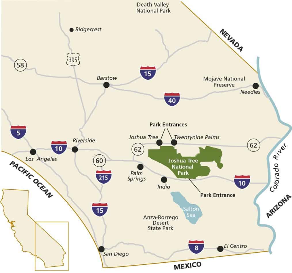
Joshua Tree National Park
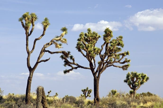
Many plant and animals make their home within Joshua Tree National Park’s approximately 800,000 acres, including its namesake, the Joshua tree or yucca brevifolia. Many of the 2.8 million visitors come to the park each year to gander at the strange-looking trees that look like they were pulled from a Dr. Seuss book. They also come for the dark night skies, hiking, camping, photography, rock climbing, and taking in the beautiful desert scenery. The park is located just a few hours outside Los Angeles, San Diego, Las Vegas, and Phoenix, where the Mojave and the Colorado deserts come together.
Winter Climate
Summertime in this area can be somewhat uncomfortable, with temps often reaching over 100 degrees Fahrenheit. Therefore the most popular times to visit Joshua Tree National Park are October through May. The park can get super packed in the fall and spring months, making winter the prime time to go if you want to beat the crowds. Those winter camping will find temps in the 60s during the day that chill down to the mid to low 30s at night.
Getting There
There are three entrances to the park, and its large size means that driving from attraction to attraction within the park is the best means to get around. However, it’s important to note that cell service is notoriously poor throughout the park, so it’s good to plan your route ahead of time and use an app that allows you to download maps for offline use, like the RV Life GPS app.
- The West Entrance is located near Joshua Tree Village.
- The North Entrance is in Twentynine Palms
- The South Entrance is near Cottonwood Spring, about 25 miles east of Indio.
National Park Service, Public domain, via Wikimedia Commons
Hiking In Joshua Tree National Park
While hiking is one of the most popular things to do in the park, they don’t allow pets on any trails, except for the paved Oasis of Mara Trail. However, according to the NPS, “Anywhere you can drive your vehicle, you can go with your leashed pet.” So taking a walk with Fido down some of the many unpaved roads is acceptable. Be aware that some unpaved roads require a 4-wheel drive and/or high-clearance vehicle.
Additionally, there are few to no services in the park, so make sure you bring plenty of food and water for you and your two or four-legged family members. Below are three popular hikes to get you started, but hiking maps can be picked up at park visitor’s centers if you’re planning on exploring the area for a few days.
Arch Rock Trail
Arch Rock Trail is one of the most popular trails in the park and can be reached via the Twin Tanks Parking lot (Arch Rock Trailhead). The trail is a .6-mile hike that leads to a .2-mile loop. The main feature of this trail is the arch rock formation located halfway along the loop.
Oasis of Mara
This trail is the only hike that allows leashed pets and can be accessed through the Oasis Visitor Center in Twentynine Palms. The 0.5-mile trail shows visitors how the Oasis of Mara has been used by wildlife and people throughout time.
Ryan Mountain
Those looking for a more challenging hike will enjoy this 3-mile trek with a 1,050-foot elevation gain to reach the summit of Ryan Mountain. Though it is considered a challenging hike, it is one of the most popular hikes in the park. The trail is accessible from the parking area between Sheep Pass and Ryan Campground.
Winter Camping at Joshua Tree National Park
There are eight campgrounds within the park. Five campgrounds require a reservation while three are first-come. Though there is an abundance of campgrounds, only two have a dump station and access to water.
Black Rock Campground sports 99 sites and is located in the park’s northwest corner. It features restrooms, water, and a dump station nearby. Shopping facilities are only five miles away, which is a plus considering there are no food services within the park. Campsites vary in size, but many will accommodate both tents and RVs.
Cottonwood Campground has 62 sites and can accommodate an overall combined RV length (including a towed vehicle) of up to 35 feet. It has potable water, flush toilets, and a dump station. Reservations are required during the busy season (September-May).
Belle Campground doesn’t have water or a dump station, but this small (18 site) campground has a rather high rating of 9.1 out of 10 on RV Life Campgrounds. It is first-come, first-served, and sports pit toilets. Those wishing to experience the amazing dark skies the park has to offer will enjoy this campground.
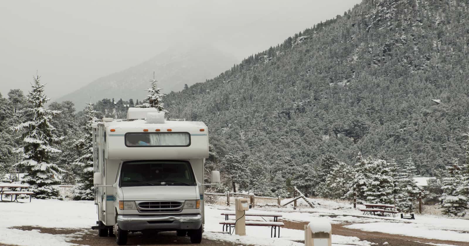
Death Valley National Park
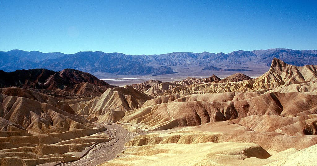
Death Valley is the largest National Park in the lower 48 states. It is located in a below-sea-level basin and is known for being a land of extremes. Visitors will find one of the hottest places on earth, reaching 120+ degrees in the summer months. However, visitors will find themselves surrounded by towering snow-dusted peaks in the winter. After one of the infrequent rainstorms, vast fields of wildflowers will bloom.
Winter Climate
Winter is one of the best times to experience the barren salt flats, mountains, canyons, dunes, and springs. Daytime temperatures are in the 70s during the day and drop to the low 30s at night. It rarely rains in Death Valley, so you can count on warm sunny days on your winter stay. Like many other desert locations, winter is not necessarily the slowest time to visit Death Valley, so plan your winter camping trip early in the season and expect bigger crowds.
Getting There
The main road through Death Valley from east to west is California Highway 190. The 190 can be reached from Route 395, State Route 178, Hwy 136, and State Route 127.
Hiking in Death Valley National Park
The best time to hike in Death Valley is from November through March. There are a few constructed trails in the park, but the area is vast and desolate, so many people simply choose a direction. Below are three popular hikes throughout the park.
Badwater Salt Flat
This easy out and back hike takes hikers to the lowest point in North America. There is an ADA-accessible ramp that leads down to the boardwalk. The parking area is paved with large spaces for RVs and is located 17 miles south of Furnace Creek on Badwater Road.
Badlands Loop
This moderate 2.7-mile loop has some fantastic views. The parking area has RV parking at Zabriskie Point on CA-190.
“The Badlands Loop starts from the most popular viewpoint in the park – Zabriskie Point. The loop winds through colorful badlands composed of an ancient lakebed. Pay close attention as you weave through this maze of narrow drainages looking for small signs at each major intersection.” – NPS
Telescope Peak
Telescope Peak is the highest summit in Death Valley National Park and sits at 11,049 feet. The 14 miles out-and-back trek with a 3,000-foot elevation gain is definitely not an easy hike, but many find the views at the top worth it.
The trail to Telescope Peak begins from Mahogany Flat Campground, but low clearance vehicles may have to park at the Charcoal Kilns and hike the additional 1.5 miles to the campground.
Winter Camping at Death Valley National Park
The park has several campgrounds run by the park service and privately-owned campgrounds.
Stovepipe Wells Village is an RV park in the middle of Death Valley off the 190. The park offers 14 full-hookup RV sites across from the local General Store, and the fee includes access to the swimming pool and Wi-Fi access in the Stovepipe Wells Village Hotel. There is also a restaurant nearby as well.
Furnace Creek Campground is the only NPS run campground in the park with hookups. It has 136 campsites, drinking water, picnic tables, flush toilets, a dump station along with several full hookup sites. It’s also the only NPS campground in the park that allows reservations.
Mesquite Spring Campground is located at the north end of the park. It does not have electric hookups, but it does sport potable water and a dump station. Forty sites are available, and each site has a fire grate and picnic table.
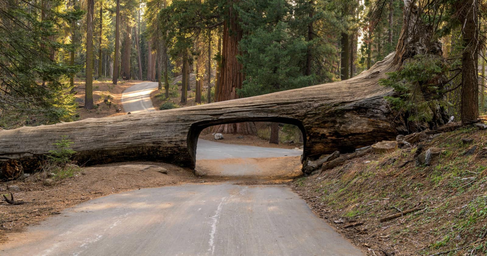
Redwood National Park
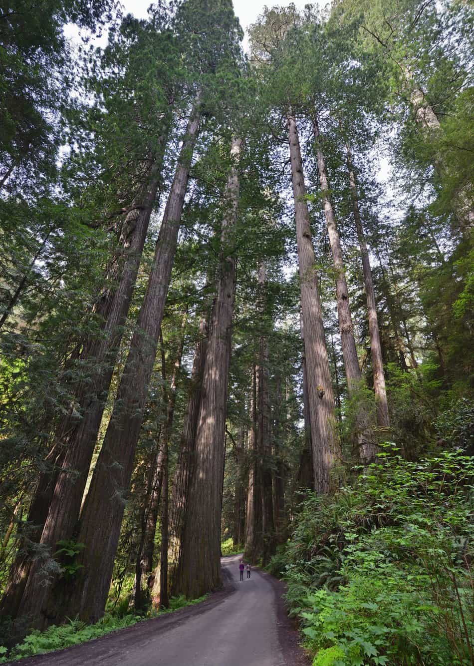
The coast of northern California hosts some of the most amazing giant and ancient trees on the planet. Some have been alive well for over 2,000 years. But Redwood National Park isn’t just the tallest trees in the world. It also protects vast prairies, rivers, and 40 miles of beautiful coastline.
“An amazing diversity of life exists at Redwood National and State Parks (RNSP). The ancient coast redwood ecosystem preserved in the parks contains some of the planet’s most majestic forests. Here, banana slugs, gray whales, Douglas-fir, black bears, and sea anemones are equally at home with redwoods.” – NPS
Winter Climate
Due to the coastal influences, temps are pretty consistent throughout the year. Highs range in the low-60s°F to the high 50s°F, while lows drop to the low to mid-40s°F. Winter is an excellent time to visit the park for those looking to find quiet solace on a beautiful forest hiking trail as it is the least populated time. Though winter camping temps are nice, it tends to be the rainiest season in the park, but many say the forest takes on new sights and sounds when experienced in the rain.
Getting There
Parklands stretch roughly 50 miles from Crescent City, CA (near the Oregon border) to the Redwood Creek watershed south of Orick, CA. The main highway through the park is Highway 101, and it is free to enter the park. Visitors will find five information centers along the north-south corridor.
Hiking in Redwood National Park
Just about all the trails in the Redwood National Park will be excellent, so it’s just a matter of picking one and enjoying nature. The terrain varies in the park, from the tall trees to the coastal waters, making for some truly unique outdoor experiences.
Simpson-Reed Trail
You can access this ADA accessible trail in the northern part of the parks from Highway 199 between Crescent City and Hiouchi. This 0.8 mile (1.3 km) trail takes you around redwoods, creeks, ferns, hemlocks, huckleberries, and other forest features and wildlife. It also features interpretive wayside panels that provide information on the area’s history. There is, however, no parking for RVs or vehicles with trailers.
Tide Pool Access via the Coastal Trail Trailhead
You can find some excellent tide pools at Endert’s Beach, which can be accessed just south of the Crescent Beach Overlook on the south end of Crescent Beach Drive. To get to the beach, hike from Coastal Trail trailhead to the Nickel Creek campground and down to the small pocket beach. You can find tidepools just north of the beach.
Trillium Falls Trail
Redwood National Park isn’t just trees. It also has some waterfalls. Trillium Falls is rated as a moderate hike because it gains some elevation. However, it is a relatively short 2.6 miles. The hike winds through old-growth redwood forest. Hikers will see flowers, ferns, and fir trees along the trail and end up at Trillium Falls (a 10-foot waterfall). Visitors may also glimpse the Roosevelt Elk herds that live in the park.
Winter Camping at Redwood National Park
Out of the 4 developed campgrounds in the national park, 3 are open year-round and offer primitive tent and RV camping. From north to south they include:
Jedediah Smith Campground is 10 miles east of Crescent City on Hwy 199. A total of 86 sites accommodate RVs under 25 feet long and include picnic tables, fire pits, and barbecues. Other amenities include hot showers and a dump station. Because Jedediah Smith is located along the banks of the Smith River, campers can enjoy swimming and fishing among other activities.
Elk Prairie Campground is tucked away in the ancient coastal redwoods of Prairie Creek Redwoods State Park, 6 miles north of Orick. RVs under 27 feet long are recommended in this 75-site campground.
Gold Bluffs Beach Campground is also located in Prairie Creek Redwoods State Park but 10 miles north of Orick. Here, campers have access to a secluded stretch of beach, Fern Canyon, and miles of trails. The campground includes 26 sites, and rigs up to 24 feet long are recommended. Solar showers and restrooms are available for use.
Where is your favorite winter camping location? Let us know in the comments.